Census Returns
There has been a census return once every ten years from 1841 onwards. The only exception was in 1941 because of war time. The details of these census’ are made available to the public when they are 100 years old. Therefore it is currently possible to look up the details for Heyford in 1841, 1851, 1861, 1871, 1881, and 1891. They are held in the Public Record Office at Wootton Park.
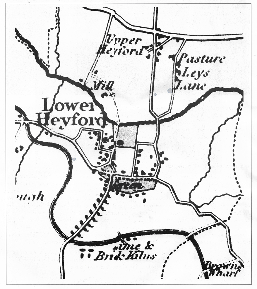
Details from the Bryants map of 1837
Census returns are wonderful documents because they list the names of every occupant in the village, giving details of their ages, their occupations, where they were born, and their relationship to the head of the household (eg wife, son, servant, etc). The returns for Heyford during the second half of the nineteenth century show an abundance of agricultural labourers, brickworkers and furnace workers. They show a whole variety of crafts and trades people such as lacemakers, laundresses, beer sellers, coal merchants. bakers etc, and also those employed in domestic service at the Manor House and Rectory.
The census returns also state the address of the householder, but most of the returns for Heyford for this period give only very general descriptions such as “Heyford Village” or “The Green”. However the Census return of 1871 gives very detailed street names, many of which no longer exist. The following paragraphs takes us through the returns in the order in which they are listed. This may or may not be the same order as the route followed by the enumerator, but if we assume that it is, we can speculate about where these lost street names may have been located.
Brook Farm
Watery Lane
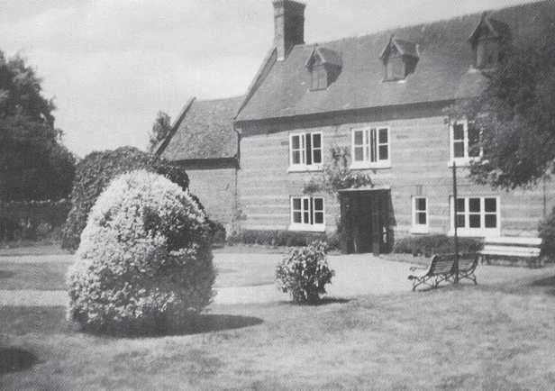
The first four households listed by the enumerator were in Back Lane. Church Lane was at one time called Back Lane, but could the Back Lane listed here have been what is now Watery Lane? The next entries in the returns are Heyford Cottage, occupied by John Smith and Farm House occupied by George Tarry, farmer of 60 acres. Was this one of the former farm houses in Watery Lane? Perhaps Brook Farm?
Middle Street
The enumerator then seems to move through to what we now know as Middle Street because the next five entries are: the School House in Middle Lane, occupied by Thomas Stanton, schoolmaster, the Olde Sun Inn occupied by George Attwood, tailor and innkeeper; and three other houses in Middle Street. From here, he seems to have walked alongside the Green, where there were then no houses, to the Foresters Arms.
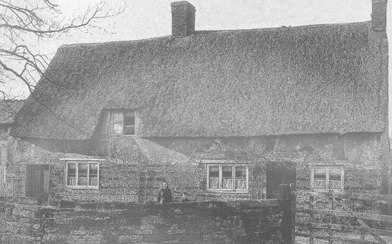
Heyford Cottage prior to 1880

A view of the school site and farmhouse prior to 1880

Church Street
There are then many entries listed in the area that we now know as Church Street. This was obviously the heart of the village as there are eighty households listed in this area. It can only be speculation, but the journey seems to go right down to the Manor House, then on to the Church and Rectory, and all the way back up to the Green. The entries are as follows: The Foresters Arms, occupied by John Wright; the Primitive Methodist Chapel, the sub Post Office, occupied by William Treadwell, bricklayer, and his wife Millicent; seven houses in Billing’s Yard; seven houses in Front Street; the Manor House; ten more houses in Front Street; eleven houses in Masters Row; one house in Church Street; the Rectory; the Church; 15 more houses in Church Street, including Edward Capel, butcher; 2 houses in Robinsons Yard; one more house in Church Street; one more in Front Street; six in School House Lane; and finally seventeen in Grocers Row.
An old stone house on the site of what is now 5 Manor Walk
The Green
The journey then seems to take us around round the Green. The entries are as follows: twenty-eight households listed as The Green; then Farmhouse, occupied by Thomas Starmer, farmer of 213 acres; thirteen houses in The Barracks; and four at Crabtree Corner. Where exactly were these places?
Weedon Road
Next he goes out along the Weedon Road towards Stowe Hill: two houses in Stowe Hill Lane; one called Primrose Cottage; one called Field House; two at a place called Pincham; then High House, occupied by William Thompson, boatbuilder; two at Flore Lane, both coal merchants; six at Stowe Hill; the Globe Inn, since renamed the Narrowboat; four at Stowe Hill Yard; the Anchor Inn, possibly the building across the A5 from the Narrowboat; and two more houses in Weedon Road. The enumerator seems to have walked along the A5, taking in one house at Tanborough and two at Aldermans Hill before turning back into the village down Furnace Lane.
Furnace Lane
Finally we come back into the village down Furnace Lane. There are four houses in Furnace Road, one at Heyford Wharf, one referred to as the Bricklayers Arms, occupied by John Dunkley, beer seller; and five in Wrights Yard, including George Payne, furnace keeper. Here, the enumerators journey ends.
Stephen Ferneyhough
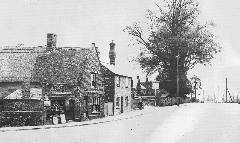
Two views of the shop and post office as they appeared before the war

This photo lent by Judy Armitage, shows the newsagents and the group of cottages behind since demolished.
This view shows the old Post Office, demolished in 1950s, Photo also lent by Judy Armitage
~~
Extract from “The Story of Heyford” – Local book series published in the late 1990’s
Volume 4 of 4 | Chapter 2 of 8 | Pages 7 to 11
